

Bears, gators, green lasers, hobbit feet, mouth sores, epic single track, hypothermia, search and rescue, where’s that damn dam, crash and burn off an 8 foot berm, beautiful Florida wilderness, great times!
How do you describe a 72-hour, non-stop adventure race? I don’t think you really can. It’s almost impossible to describe, especially to those that have never done one. When I try to tell people about it, I can’t seem to capture how exciting, rewarding, tough, exhausting and ultimately fun a race like this is. In addition, most people seem to have a 2 minute attention span and a 3-day race isn’t something that you can describe with an elevator pitch. So, for those that enjoy the archaic hobby of reading things longer than a Facebook post, here’s my vain attempt…
Follow along with full race maps here
Section 1: Trek (3 miles) Ponce Inlet
 I guess the race started at Ponce Inlet. I find it hilarious that when people ask me where the race started, I really can’t tell them. “Somewhere on the east coast of Florida” is what I usually answer. “But, I know we finished at the Plantation Inn & Golf Resort in Crystal River.” You see, before the race begins and we’re given our 48 maps, we don’t know where the race will start. We know where it ends because that’s where we parked our cars, and eventually you’ll want to find your car.
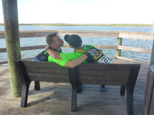
 After a 3hr bus ride to the other side of Florida, we had enough time to drop the browns off at the Super Bowl, butter the biscuits, and do a last minute gear check before embarking on our epic race. I’m usually super nervous until I find the first checkpoint (CP) and truly get my bearing. For this race, the first CP was along a pier right in front of us, even Team Disoriented can nail that.
 The rest of the section was a simple trek around Ponce Inlet, hitting a couple of local spots, and taking photos along the way.
Section 2: Paddle (8.5 miles) Spruce Creek
 There is nothing sweeter than the sound of oyster shells scraping along the bottom of your fiberglass canoe, trying to rip it open like the Titanic. Of course, being the conscientious adventure racers that we are, we would never, ever subject our canoe to that type of abuse. But then again, we weren’t using our canoe…

We followed a few teams through the labyrinth of shallow oyster beds, collecting 2 CPs and ending with a nice little portage. How long was the portage you ask? Oh, about ¼ mile passed pissed off. The canoe drop was just before we got started on the really good curse words.

Section 3: Bike (48 miles) East Coast
Our first bike section of the race started with a time trial of the Spruce Creek Bike Trail Network. Follow the trail they said. You can’t get lost they said. Hmm funny how we ran into 2 other teams that had gone around in a big loop after missing a critical turn. We decided to throttle back our mad mountain biking skilz (yeah, that’s skilz with a z) to not mess up the navigation on this. We definitely didn’t break any time trial records here, but we did get all the CPs.
After the time trial, we had 4 other CPs to collect along the way to the next section. This was a mix of off-road/jeep trails and some city roads. One of the cool CPs was at the Sopotnick’s Cabbage Patch Bar, a well-known bike bar…for dudes with tats, skull rings, chains, and leather jackets. Not for dudes in spandex shorts on bicycles. Actually, they were really cool and allowed us to get a drink, so long as we got the hell out of there. The last CP for this leg was at JC’s Bikes & Boards. Adventure South Racing was stopped here getting their derailleur fixed. How awesome is that?! If you’re ever in the area and need to stop at a bike shop, hit them up.

Section 4: Trek (4 miles) Lake Beresford Park

Here’s the dealio. I hate cutoffs, especially early cutoffs. Yeah yeah, I know, strategery is a part of adventure racing blah blah blah. My issue is that only 2 teams, Rev3 & Good ‘Nuff, cleared the course up to Section 4 and made the time cutoff (and hats off to both teams for making it). We missed it by 20 minutes, clearing the course up to that point. Unfortunately, the early cutoff set the race for us and many other teams and removed the possibility for any late race rallies. By 4:30PM on the first day, both top teams knew that all they had to do was clear the course and they were assured a 1-2 place finish. Mentally, this is a strong position to be in…much different than knowing a team can come from behind and take a spot from you. Oh well. Our mistake. We totally own it and know we should have pushed harder in the beginning.
Section 5: Paddle (11 miles) Snake Creek
We paddled up the aptly named Snake Creek as it twisted its way northwest towards Hontoon Island State Park, where it eventually meets the St. Johns River. At Hontoon Island, we disembarked to search for “CP14 – Indian Mound on Hontoon Island.”
Now, I don’t know about you, but I had no idea that Indian Mounds looked like park benches. I guess if I were an Indian building a mound, I might want a bench on top of the mound so that I could take a nice leisurely view of the surrounding forest, maybe eat a sandwich or opossum, or whatever Indians ate back then. I don’t really know, but I do know that ambiguous clues are no fun. Especially when there isn’t a control at the location. Were we on the right trail? Should there be a sign that says “Indian Mound”? Are we supposed to ignore the “Trail Ends Here” sign and go look for an Indian mound? We decided to reattack this CP from another trail and ended up in the same location. So we snapped a photo of the bench and said &^@#! it after wasting 30-40 minutes.

This should have been a quick five minute punch, “CP14 – Park bench at end of trail (this is an Indian Mound)” would have been unambiguous and let teams know of the historical artifact we were on.
Section 6: Trek (19 miles) St. Francis
I love night treks. No, really, I do. There is something indescribably exciting and enchanting about night trekking. It’s quiet and spooky and fun all at the same time. Owls hoot, critters and creatures run about in the woods around you. You feel like there isn’t another soul around for miles. It’s just mesmerizing. We fast trekked this section, nailing the navigation and making pretty good time while enjoying each other’s company and trying not to migrate onto private property. Walking onto private property at 3AM in the middle of the woods is no bueno.
Section 7: Bike (22 miles) Ocala Paisley Woods
Section 7 was a 22 mile bike loop for 2 CPs that some teams opted not to do. That’s a pretty good decision when you know that after the 22 mile loop, you had another 30 miles on the bike before the next transition area (TA). That’s a total of 7-8 hours of butt-blistering biking. Our plan was to do the short loop for 1 point and to skip the long loop. We were looking for “CP19 – Bike Loop Trail Cutoff Sign” which translated into American means “CP19 – Alexander Springs Sign”. Maybe other teams weren’t confused, but I’m a pretty simple guy. If someone says, take a photo of the blue sign, I’m looking for a blue sign. And if the clue says, “Bike Loop Trail Cutoff Sign” then I’m looking for a sign that says, “Bike Loop Trail Cutoff” or “Bike Cutoff” or “Trail Cutoff” or “Cutoff” or at least 1 of the 4 words used in the clue. I’m not looking for a sign that says’ “Peanuts this way” or “Unicorns are Awesome” but maybe that’s just me.

After doing ½ of the first loop, Todd was super excited about going on to do the long loop as well. Especially since doing so might make us miss the O-course cutoff at Sunnyhill for 9 points. I can fondly remember the words of encouragement and the hug he gave me once we got to the top of the loop…

Section 8: Bike (30 miles) Ocala National Forest
Once we finished the double bike loop, we still had 30 miles of trail biking to do through the Ocala National Forest. The clue sheet offered this sage advice, “Select checkpoints in this ride wisely, many of the roads and trails along this segment can be sandy or muddy.” I’m not sure how you select roads and trails wisely when you don’t know the area, I mean you might as well say, “Shake your Magic 8-Ball and rattle some chicken bones for good juju because if you don’t you’ll be stuck in 8 inches of the softest damn sand you’ve ever tried to ride through.”

Riding in sugar sand is like…well, it’s like CRAP! That’s the best I have. It’s crap, piled on top of crap.
Section 9: O-Course (? miles) Sunnyhill

We rode into Sunnyhill to start the O-Course and were greeted with gator-filled canals that created a labyrinth of water. Picking the wrong path took you to a dead-end where the only options were to turn back or go through the canal. After seeing a few toothsome gators hiding in the duckweed, we decided there would be no swimming or canal crossings on this section.

After plotting 9 UTM points, we headed out. There was a 9PM cutoff to finish this section, but we had plenty of time. Once out on the course, we realized how far apart the controls were and that the nav wasn’t going to be as straight forward as we originally thought. Our first route choice took us to a dead-end where we had to turn back. The distances seemed to be much further than indicated on the map, but looking at Google Maps post-race, the scale was right on. I think it was more of an optical illusion because the land was flat and treeless and you could see a long distance. We struggled a bit on this section. I ended up dropping my watch on the way to CP33 – River Cabin and had to backtrack to find it. Green watch dropped in green grass…yeah that was about as fun as you can imagine. This was my 2nd watch, the first I lost at USARA Nationals last year and I wasn’t about to leave this one behind. Luckily Ana was running strong and could race ahead to look for it while Todd and I limped along.
CP34 – Big Cedar gave us the most trouble as we tried twice to attack it from the west. After two failed attempts, we were going to bail on it, but since we had to go past it to finish the course, we decided to attack it once more from the east. As we got close to the attack point, we had a large black bear walk out of the woods onto the trail in front of us. We were contemplating what to do next until the second, larger bear stepped out onto the trail. That pretty much solidified our decision to get the hell out of there. Now, maybe others would have kept moving towards the bears, but I’ve never heard anyone advising that you should walk towards a bear with a backpack full of food when it stands between you and were you want to go. I’m sure some have tried it. There’s a special award for those people, a Darwin Award.
Our next CP was CP30 – Small Clearing for Bears. Just fantastic. Dusk is settling in, we’ve already seen two bears, and now we’re heading into a small clearing for bears. For five minutes we hunted around a clearing full of bear poop with backpacks full of nuts, berries, chocolate…you know all those things that bears eat. I felt like we were walking snack packs for the bears. Hey BooBoo! Why don’t we go eat one of those walking picnic baskets?

By now, I was mentally drained and couldn’t nav anymore. I handed the map over to Todd and he finished up the O-Course, guiding us to the remaining checkpoints and the transition area. During this section there was also a full-on search and rescue going on. We didn’t know if someone was attacked by a bear, eaten by an alligator, or lost on the Oklawaha paddle. With a helicopter flying overhead, and sirens going off, we were really worried for whoever had called for help. But, that’s a story you’ll have to read about on the Canyoneros blog post.

Section 10: Paddle (18 miles) Oklawaha
Forever to be known as “The Paddle”, the Oklawaha paddle was just about the hardest section of any race we’ve done so far. Our first plan was to sleep for 20-30 minutes at the TA before heading out on the paddle. So, we ate a Cup’O’Noodles and putzed around the TA wasting a lot of time before deciding that we should go out, paddle up to the dam and sleep there for 20-30 minutes before finishing the paddle. That would break up the 5 hour paddle and allow us some sleep. I knew it was forecasted to get cold and the sooner we got the paddle done, the better off we would be.
Exhausted, we launched our canoe and paddled, collecting 2 CPs along the way. By the time we reached the dam, Ana was soaked and freezing and we were all on the verge of collapse. We portaged our canoe around the dam and tried to catch 20 minutes of sleep in the women’s bathroom. You know you’re pretty stinking tired if you’re willing to curl up on a public bathroom floor to get some rest. After 20 minutes of shivering and shaking without sleeping, we decided to hit the water again. By now, Ana was wrapped in her Survive Outdoors Longer Emergency Blanket, cold weather gear, rain gear and puffy jacket.

Little did we know how miserable a 3 hour paddle would be after racing for 36 solid hours and having the temperature drop to 38 degrees. Along the paddle I saw green lasers being shot across the river, Ana saw castles, Todd saw little men. We all heard voices and felt that at times we were either paddling uphill or downhill. With the change in temperature, there was such a mist on the river that Ana couldn’t see anything in front of her. It was like driving in fog with high beams on. Imagine someone threw a white sheet over your head and then told you to paddle while they constantly threw cups of cold water at your face. Good times, right?
We played word games and told stories to stay awake as we bounced off lily pads on either side of the river and avoided downed trees just seconds before crashing into them. We were in total wilderness and a capsized canoe, in our state, would not have been good.
However, it wasn’t until we finally landed and had to hike 1.5 miles to the transition area that we realized just how cold we were. We were completely soaked and with uncontrollable shaking and chattering teeth, we carried all of our paddling gear to the TA where the most awesome volunteers had a small fire and hot chocolate available. Chris and Sonia, you were literally life savers. Thank you!
Section 11: Trek (9 miles) Marshall Swamp
Before heading out on the trek, we decided to grab an hour sleep at the TA. This was our first sleep of the race and we went unconscious as soon as we stopped moving. This trek was along the Florida National Scenic Trail to the Historic Santos Recreation Area. There weren’t any real navigation decisions to be made here and we simply followed the trail to the TA.

Section 12: Bike (50 miles) Santos
For cross country trail riding in Florida, it doesn’t get any better than Santos. Maintained by the Ocala Mountain Bike Association this trail has it all: epic drops, steep climbs, technical stuff, and fast flowing single track.
With Todd picking the lines, we “flew” through this section. At least in my mind I was flying, and looking pretty awesome doing it. You’ll just have to take my word for it.
After getting through the climbs and switchbacks on Nayls and Ern N Burn, Ana was ready for a stiff drink. I was ready to get off the bike for awhile, but we still had miles to go.
 The last single track section, Tricycle, seemed to last FOR…E…VER! After the previous, more technical sections that made you stay focused, this part was a little more mundane and having only 1 hour of sleep so far, it was getting hard to keep our head in the game. We weren’t sure where the last CP was, just that it was along the trail somewhere. It’s always a little unnerving not knowing where the controls are, but the race directors did a great job placing them so you couldn’t miss them. Had the race directors placed the CPs on the map, teams could easily bypass the more technical and fun parts of the trail in exchange for getting to the controls faster.

Once we got out of Santos, we still had a few miles of street riding to do before reaching the next TA. Once we hit the road, we met up with Nativos Colombia and a few other teams. Nativos Colombia are crazy fast on the bike and flew past us. I knew we weren’t the fastest cyclists out there but man what an eye opener. It must be our bikes…yeah, definitely our bikes. And a loud hub, I need a loud hub. I heard they make you go crazy fast.
The last bike section was along the Withlacoochee State Trail, a beautiful 46 mile paved rails to trails section.

Section 13: O-Course (? miles) Citrus
The O-course section was a dark zone where all teams were stopped until 5AM Sunday morning. While here, they had the option of completing up to four O-courses of varying difficulty. The way it worked is that you picked one of the four courses and returned to the TA after completing each one and before heading out on the next one. Once your team decided it was finished, you were off the race clock until the dark zone was lifted.

I’m not sure what time we arrived, but it was after dark and we knew we were in for a long night if we wanted to collect all four available points. After sucking down about 3 hamburgers, we headed off on our first O-course.

Clearing the first course was pretty easy, but then we couldn’t find the Transition Area again. I can’t explain how frustrating it is to be able to locate a 12in x 12in orange and white flag out in the middle of a forest and then not be able to locate a clearing with two U-Haul trucks, 100+ bicycles, and racers milling about. We stumbled around for a little while, ending up in the regular campers section of the park before finally finding the Transition Area again.
Due to Todd’s bloodhound-like ability to sniff out controls, we didn’t have much trouble finding any of the CPs except for CP2 on map 4 (shown below) if anyone is following along on the maps.

When we bushwhacked straight from CP1 to CP2, we thought we were looking for a CP on a hill, but we should have been looking for a CP in a sink. They’re kinda like opposites, ya know. So, we scoured the hill to the south of CP2 for about 45 minutes until we decided to reorient ourselves by going to the trail junction north of us and pace counting to the correct “hill”. When our pace counting put us smack dab in the middle of the sink, I realized my map reading error. Once in the correct location, we found the CP easily. Oh, the fun we had!

By now, we were sleepwalking zombies. It was probably close to 2AM and we hadn’t slept more than an hour in the last 65 hours. Once again I was brain dead and handed the maps over to Todd, who finished up the O-Course and led us to the Transition Area. Along the way we entered this massive sink that was also a prescribed burn. We came across a downed pine tree smoldering with glowing red embers inside of it. At the bottom of the sink was a huge tree with a CP hanging from it. I really wish we would have taken a picture of the area as it was surreal. But, the only thing on our mind was finishing this section and grabbing an hour of sleep before the dark zone lifted.
Section 14: Bike (28 miles) West Coast
We got back to the Transition Area at 3AM, just enough time to sleep for an hour before waking at 4AM in preparation for the 5AM race restart. Dragging yourself out of a warm sleeping bag after 1 hour of sleep, when it’s 45 degrees outside…AWESOME!
The race restart had us blasting down clay roads with washed out sections ready to grab your front tire and launch you head first into the darkness. Being the super bikers that we are, we got to watch taillights disappear into the night ahead of us. We had a couple of CPs to pick up along the way to the final boat section. This was a 28 mile final sprint and our team formed a pace line, more to look cool than to move any faster. Ana, always the unstoppable one, took the lead and pulled Todd and me along the streets of Crystal River.

The last CP on this section was supposed to be collected on foot, but since the lead teams were allowed to go on bike, we were all given the option. This rooty, narrow berm of a trail was not meant for bike riding, at least not for us to be bike riding. On the way back from punching the control, Ana got close and personal with the mucky waters on either side of the berm.

I looked back just in time to see her fly over her handlebars and crash face first into the muck 6 feet below. Thank goodness she saved her bike from any damage by having it land on top of her. I would have taken a picture if I wasn’t so worried that she was okay…and worried that she’d slap the crap out of me if I tried.
 Later on I was able to snap this photo of her post-crash bad assery 🙂
Section 15: Paddle (8 miles) Fort Island Beach
Here were our choices, paddle 8 miles into a blustery headwind or go hit Denny’s for the Grand Slam special…
There is nothing better than rolling into a Denny’s after 72 hours of racing and smelling like swamp funk. After 3 days of solid racing, your body takes on a completely new level of stink. There is regular body odor, and sweaty man body odor, and then there is something I like to call Landfill funk…you know that special scent that makes you cough up a little vomit in the back of your throat on the first sniff. We were just about touching that level.
Conclusion:

Florida Xtreme nailed it! This was the race we were looking for. Difficult, wild, adventure. The maps were great, the logistics were great, the volunteers were great. Superbly ran and organized from beginning to end. We can’t thank Junos, Ron, Dave, Manny, and the entire Florida Xtreme crew enough for putting on a superb race. To the volunteers, a heartfelt thank you for making this race amazing. I know how hard you all worked out there and it is appreciated by every single racer. And of course, thank you to the two best teammates I could ever hope for.

To the race directors, two small suggestions:
- All CPs need to be unambiguous or have a marker on them. 72 hours of racing is hard enough, don’t make us guess whether we have a photo of the right thing or not…or counted the right number of benches. It’s just down right frustrating to lose a point when you know you were in the right area.
- Not being able to speak for most racers, but for me and my ego, what I really want more than prizes or t-shirts are photos. I’d rather the race directors pay someone, or get a volunteer, to take a boat load of photos of all the teams throughout the race and make them available for free. Because in the end, we’re all doing this for the memories.

OMG! Team disoriented you are awesome!!! And I agree, “I WANT PICTURES!!!”
Dave Brault from FLX arranged for photos to be taken during the Father’s Day race last year and they are awesome. Hope to see you at Earth Day next month!
We looked forward to your 2017 Sea To Sea adventure blog and were certainly not disappointed. We appreciate the preparation, time and effort your team puts into these grueling events. You do a great job describing the different phases of the race and the photos help us understand how tough the course really is. You have an amazing team and we look forward to your next adventure……..
Thank you! That was the nicest comment we’ve ever received. Thank you for taking the time to read our blog posts, I hope it gave you a laugh or two.