Lighter Knot 8Hr AR

The Lighter Knot AR, henceforth to be known as the, “I can’t find my own bunghole with two hands and a map” Adventure Race.

Lighter Knot

Once again FLX‘s Dynamic Duo of Craig and John Sheriff put together an amazing 8Hr Elite Adventure Race at the Bulow Plantation Ruins State Park.  This was the 3rd in a series of ‘Sea to Sea’ highlights race series where a different section of the Sea to Sea is covered. The overall winners of the three-part series would receive a free entry into the 2016 Sea to Sea.  Having raced the Reunion with Rice Creek, and being the only team to have raced in 2 of the 3 races in the series, we figured as long as we showed up and finished the race, we should win the free entry into the 2016 Sea to Sea.  For this race, I’d be teaming up with Todd Binkley who I’d raced with at the Blue Ridge Adventure Race.

Maps to follow the play-by-play:

ELITE FOOT CLUES R FOOT Q FOOT B FOOT ELITE CP CLUES ELITE LARGE MAP

Boat

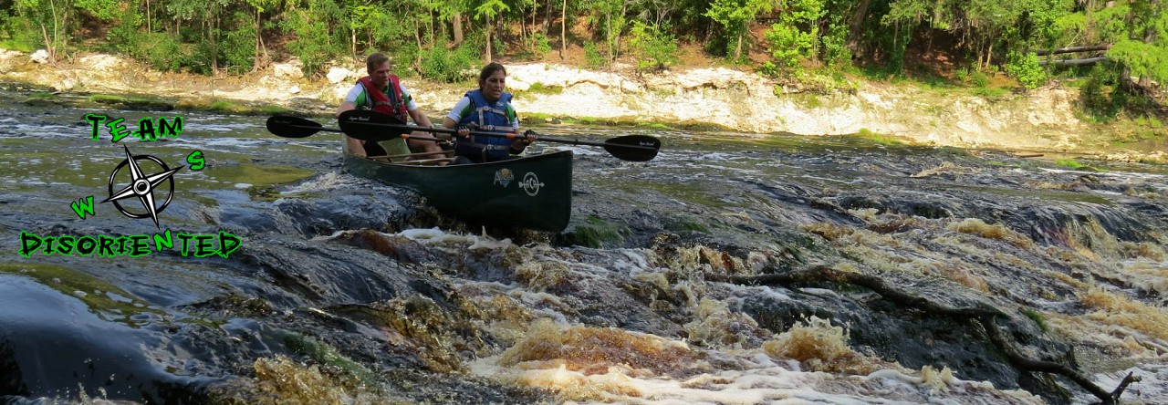
Well, if you’re going to have a bad race, it might as well start off crappy…and that’s exactly how this one started.  Due to Hurricane Joaquin, the super moon, or the gravitational pull of my ego coming off of some really good race finishes, the water level at Bulow Creek was higher than it had been since, well, some dude named Noah decided to build a boat.  I couldn’t match what I was seeing to what the map was telling me, but I knew that I had to follow the shoreline south.  We were all on a small peninsula and there was a crowd of people trying to get their boats in the water.  Not wanting to wait in line, we launched at the end of the peninsula, not more than 5 feet away, and that ended up being a huge mistake

You see, in central Florida they have these marshy areas with low-lying grasses and canals cut through them to create labyrinths to befuddle the minds of adventure racers.  While I’m used to seeing waterways marked in blue, the map showed these channels in red.

mapaerial

I wrongly assumed that once launched, we could make our way west to the shoreline.  But oh no, we were stuck in some channel taking us southeast, rather than south.  Not understanding where we were, I knew we had to boat-whack across the marshland and find a path west.  You can see our meandering site-seeing tour highlighted in red.  The smart teams traveled the yellow path.  The launch point is marked with a green star.

path2

In hindsight, we could have continued south and still made our way to the checkpoint, but at that point I didn’t know where I was.

After collecting CP1 and CP2, I was still making mistakes trying to match the waterway to the map, but once we got on the main creek we were doing okay.  That is, until we decided to portage the boat rather than try to canoe under a low bridge.  I swear it looked like the boat wouldn’t fit, so I decided to portage around.  We grabbed the canoe and when I went to pull it over a guardrail, I slammed my knee into the rail.  It was an explosion of pain and I dropped to the ground.  It took me at least 10 minutes to collect myself and be able to move on.  Todd was trying his best to help, but there really was nothing he could do.  I knew I wouldn’t be able to run any of the race and I was wondering if I’d even be able to bike.

Foot 1

At the furthest Boat checkpoint, we were surprised by a foot section.  We were given a new map with 7 foot controls.  The first two (B6 and B1) we found without difficulty, but we couldn’t find B2 after shooting a bearing from B1 and pace counting.  So, we did a back-bearing and returned to B1 and reattacked B2.  Todd spotted the control but we were off by at least 30-40 feet.

Foot1

From B2 we measured a bearing of 30 degrees and shot off for B3.  But we couldn’t find it and after traveling way too far, we retreated all the way back to B2.  Consulting the map, we realized the bearing was 20 degrees, not 30, and we quickly found it.  The rest of the controls went okay and we returned to the boats for a quick paddle back to the Start/Finish to begin Bike 1.

Bike 1

The cluster of trails at the beginning gave us a little difficulty and we had to backtrack a couple of times, but nothing major.  For some reason, we didn’t measure any distances to CP14 from the trail intersection so we weren’t sure where to attack the control.  And then, we didn’t realize that the control was almost 100m into the woods.  Thinking it was right off trail, it took us a little time to find this one, but it was well worth it.  (Video blatantly stolen from Ron Eaglin)

CP15, large cat-faced pine, was another frustration for us.  Once again, not measuring the distance from a known intersection to the attack point had us missing this control as well.  Another backtrack and then off to CP16 where we were welcomed with another foot section.

Foot 2

I completely sucked on Foot 2 and I have nothing more to say about it…

Foot 2

…other than I was 1 foot away from having a really bad day.

Pygmy Rattlesnake

Bike 2

Feeling pretty defeated after Foot 2, we headed off on the last bike section.  Taking the local highways north to Bulow ruins, we were encouraged by two of Flagler Beach’s finest as they heartily cheered, “Get the F@*$ off the road!” as we pedaled against strong headwinds.  At CP24 we had another orienteering section but we were quickly running out of time.

So, we collected 4 checkpoints and raced back to the finish.  We were supposed to collect a piece of Lighter Knot and bring it back to the finish for an extra bonus point, and we didn’t even manage to do that.  Some races are just crap piled on a plate of poop.

Finish

Well, it was finally over.  Sometimes all you can do is just finish and have an ice cold beverage with your racing buddy.  Thanks Todd, for putting up with me and helping me through.

The 6 hour ride home was spent analyzing the race, icing my knee and picking off ticks.  I realized that I had tried something different this race.  I just got a watch mount for my Moscow Compass and was wearing it on the same hand that I was holding my base compass.  I use my watch compass to keep track of heading while on the bike and canoe but I use the base compass for foot orienteering and more precise navigation.  Well, it seems that having them in the same hand is NOT a good idea.

I didn’t move the base compass in the photos above, only putting the watch compass next to it.  That’s 40 degrees of error!  So many lessons learned on this one.  At least with Adventure Racing, even a bad race can be a lot of fun.

Conclusion

Craig and John Sheriff, another superb race.  You guys made it a challenge with some really interesting surprises.  A special thanks to John for the wonderful trophies, mine is sitting on my desk as I type this.  The teams out there all did an excellent job, with Ron’s team taking home the win of course.  Hats off to the volunteers, you guys were great.  And Jeff Wood, you are one funny dude.  Hope to see you out there racing soon.  Most of all, thanks to Todd, you did a great job.  We’ll see everyone again at the upcoming Turkey Burn where I’m sure we will be disoriented once more.

2015 USARA National Championship

28 hours, 11 minutes, 15 seconds

93 miles

12,289′ of elevation gain

11,660′ of elevation lost

One hell of a good time!

Two weeks after completing the 18Hr Howl at the Moon Adventure Race, we tackled the 2015 USARA National Championship with only one goal in mind, Don’t Quit.  With 58 teams from all over the US competing, this was going to be a huge race.  We knew that we were running with the big boys and girls on this one so we tried to stay out of the way, run our own race, and have a good time.  Once again, we partnered with Jake Brewer from Team Jax.  His navigation skills are beyond mine and I knew his personality was a good fit, plus he’s a horse and I wanted someone we’d have to work to keep up with.  Ha, I crack myself up.  We have to work to keep up with everyone.

IMG_2062

Anyway, the week prior to the race, we had been watching the weather hoping that it would improve.  Instead, the forecast got worse with predictions of constant rain and temperatures ranging between 58-48 degrees.  To some of you, that may sound perfect but for a couple of Floridians, wet and 50 is cold and misery.  With a week of rain heading into Nationals, the course was destined to be wet and muddy.

Prologue

The race started off with a bang as someone shot a miniature cannon to begin the race.  Soon, we were all heading into the woods to collect 6 points prior to heading off to the boats, where the real race would begin.

Due to race jitters and adrenaline, I always think that the first couple of checkpoints are the toughest and this proved to be true.  We struggled on the 2nd CP, attacking too high on a ridge and having to backtrack to a known location and re-attack.  Having collected it, we headed back to the start to grab our paddle gear and make a dash to the river below to start the race.  We were already almost last but there was a lot of racing ahead of us, and honestly we were here for the event and not even concerned about position.  Okay, maybe a little.

Boat 1 (TA1-TA2)

Boat 1 was a beautiful paddle down the Cumberland River.  The swollen river was flowing with Class I rapids that provided a little excitement.  We hadn’t had three in a canoe for a long time, so it was interesting getting our rhythm and balance back.  I was leading the navigation and we hit CP1 without any problems–it was on the tip of an island so it was impossible to miss.  CP2 though was another story. I knew we were close to the tributary for CP2, but I thought it was further downstream.  Luckily, we came across another team already on shore searching for the control.  I thought they had stopped too soon and we were about to head further downriver when their teammate came back and said that he found the control.  If it wasn’t for them, we would have blown by it and then had to struggle upstream to recover it.  I was disheartened by my nav error.

There were only 2 checkpoints on this section so off we went to find the takeout.  The canoe takeout was up a small creek on the south side of the river.  Well-hidden, we went past it at first.  Jake tucked us into a small alcove to avoid being swept downriver by the strong current while we consulted the map.  Realizing my error, we struggled back upstream to cross the river and enter the creek.  We followed the creek to the muddy takeout and struggled to drag our boats up the slippery, steep embankment to the drop off point.

canoe

King of the Mountain (TA3-TA4)

After dropping off the canoes, we “ran” to TA3 for the next challenge.  The next stage was aptly named, “King of the Mountain”, a 1250′ mountain bike climb up State Park Rd to Lee Gap.

While not the most impressive time, I was really proud of our performance on this section.  Florida is not known for its mountains and most overpasses and bridges don’t come close to 1250′ in elevation.  With shortness of breath and quads of fire, we made TA4b to start the first O-course.

O-Team Orienteering Leg (TA4b-TA4c)

The O-Team Orienteering Leg was a timed O-course with the fastest team earning bragging rights and possible a trophy or something.  We were just trying to clear it without getting too lost.  Jake took the reins as navigator and led us through without faltering.  Our time to clear was 1:55:55 while the fastest team, GOALS ARA, did it in 1:17:20.  Now, I’m not sure, but I think I captured one of the GOALS ARA team members pre-race before he had time to put on his running tights…something ain’t right about that boy.

GOALS ARA
GOALS ARA

Bike 2 (TA4c – TA5)

After finishing the O-Course, we got to fly down the mountain we just spent an hour biking up.  With brakes ablaze, we flew back to the Wilderness Trail Off-Road Park where we got to pedal and push our bikes through muddy muck in the search for 9? checkpoints.  The near-constant rain had devastated the once dry and flowing single track, turning the trails into rivulets of mud and rock.  By the time we got to the field of cows at CP13, we decided that it was best to leave CP14 and just grab CP15 on the way to the second canoe section.  We had already been on the bikes for 6+ hours and our legs were shot.  Well, mine were anyway.  Jake was churning away at the pedals like a madman.

Canoe 2 (TA5-TA5b)

We hit Cannon Creek Lake well into the night, and decided to add layers and scarf down some cheeseburgers before heading out onto the water.  Warm food and coffee was a welcomed luxury after 12+ hours of racing.  The lake was much warmer than expected, to the appreciation of Ana who is not very tolerant of the cold.  We hit the controls counter-clockwise, but had some difficulty locating CP17.  I was navigating and lost my bearing trying to follow the shoreline in the dark.  After backtracking to the reentrant between CP16 and CP17 to regroup, we made our way to CP17 without any problems.  This is also where we met up with Jake’s wife, Shelby, and their dog, Reese who had patiently waited for our arrival and cheered us on.  We even had time for this Glamour Shot in front of the decaying building.

Unfortunately, this is also where I lost my brand-new beloved Fenix PD35 flashlight 😦 Not cool.  So Fenixlighting.com, if you’re reading this (and honestly how could you not) I sure would appreciate if you’d send me a replacement.  What if I say, “Pretty Please with sugar on top!”

Bike 3 (TA5b – TA6)

Never in the history of mankind has a bike been pushed so far and for so long.  Did I mention that biking is not our strong category?  For 3 hours we pushed our bikes uphill to get from the canoe takeout to the Pine Mountain Resort Lodge where we would begin the final section.  Actually, there were some downhills.  After busting a lung and setting your hamstrings afire pushing 28lbs of metal up steep inclines, you were awarded with a handlebar clenching decent down Slippy Skippy, single track so muddy and slippery that brakes were of no use.  You can imagine a rutted out rocky trail of mud so slick, it was like trying to ride on warmed peanut butter.  The best part was the suicidal option of trying to descend the powerline trail…Nope, nope and more nope.

O-Course (TA6 – Finish)

After a quick check-in at the lodge, we hit the final O-course at 4:20AM.  The sun would be rising soon, helping us to find checkpoints, so we decided to go counter-clockwise and get the easiest but furthest controls first.  This section was a real highlight for us.  The hiking was amazing with some beautiful features such as an old railway tunnel, the stone arch, and Chained Rock.

There was even a rails to trails bridge crossing where Ana almost plummeted to her death, but I don’t have any pictures of that.  Who knew there would be a railroad bridge with trusses missing?  And who would walk on the trusses instead of the planks set aside for pedestrians…yep, that would be us.

I was really proud of the way our team was clicking together for the O-Course navigation, especially for CP23 and CP24.  Jake was leading the navigation and we took our bearing and distance measurement for CP23 then leapfrogged to it.  We had to army-crawl and bushwhack through tons of brush, but we ended up within 5-10 feet of the marker.  CP24 was about the same.  Another good bearing and distance measurement to the CP, and a long butt-slide down a reentrant until my altimeter hit 1400′ where Jake hopped the small ridge to our left and found the control.  Then it was off to our last control, CP25, where things got a little sideways.

We were pretty worn out by this time and wanted to avoid bushwhacking up and over another ridge, so we decided to first attack from the west.  All we had to do was find the mapped railroad tracks and follow them in behind the hill.  So, we ran across an open field but instead of tracks, we found a raised berm.  Not sure if we were on the now-removed tracks, and not knowing if we were on private property, we ran back across the field to the safety of the road.  I’m not really into getting shot at or having to defend myself from dogs, so I really don’t like being on someone’s property.  We then decided to attack from the east and find the tracks that way, but we came to a dead end at someone’s driveway.  Luckily, the owner stepped out at that time and allowed us to cross his property, thus avoiding a major blunder.  Once on the tracks, we found the control and made our hasty retreat.

Finish

A final death march back up to the lodge and across the finish line was all that was left.  We did the AR-shuffle as best we could on the downhills and crossed the finish after 28 hours, 11 minutes, 15 seconds putting us in 24th out of 58 teams overall.  Although it would have been great to clear the course, I couldn’t be any happier with our performance.

IMG_2065

The #1 team, Tecnu, cleared the course in 16:22:37, which is absolutely amazing.  Many thanks to my teammates, Ana and Jake, who pushed through the toughest race I’ve done to date.  Ana, you constantly amaze me!  I couldn’t wish for a better pair of people to spend 30hrs getting lost in the woods with.  Stephanie from Flying Squirrel Adventures did an amazing job as race director putting together a challenging, fun, and beautiful course.  Thank you especially for scheduling the constant rain and extra mud.  The volunteers were absolutely fantastic as always, as were our hosts at the Pine Mountain Resort Lodge (I apologize for the absolute mess we left you in our cabin).  We are grateful to Bell County  for allowing us to run through their woods and especially USARA for continuing to support and grow the “Best Damn Sport Ever.”

12079830_898933473475731_5377524775938765068_o