
Sometimes, life likes to give you a swift kick in the ass to show you who’s boss and knock your pride down a few notches. That pretty much sums up our experience at the Pangea Atomic 30-Hr Adventure Race.
First let me say that Pangea did another amazing job. We loved the course, what little bit of it we saw. The single track was amazing, the views were spectacular, and the volunteers were awesome as always.
The day before the race, we drove up to Camp Skeenah Creek. The final 40 minutes of the drive were so twisty that Ana was getting car sick in the backseat and we made her drive the rest of the way hoping that would ease her equilibrium.
Camp Skeenah is a neat place to stay, although we didn’t see much of it since we arrived after 10PM. Martha set us up in a room in the big house with 3 beds and no indoor plumbing. There, we met The Derailleurs who were settling in for the night. We went about getting our gear packed and ready before dropping off for sleep around 11:30PM. For some reason, I can never fall asleep before a race and the 2 NyQuil tabs I took didn’t help either. Next time, I’m doing shooters until I just pass out. The next morning, after some last minute prep, we headed off to the staging area
Of course, we were late getting to the staging area, but we had enough time to get somewhat setup before the maps were passed out. And that was OK. On the ride up from Florida, we talked about what our goals were for this race. Having only completed 4 races with a combined duration of 29 hours, we knew we weren’t going to do very well on this race. Plus, looking at the lineup of All-Star teams that had signed up, we knew where we were in the hierarchy.
Elite_AtomicAR_ControlDecriptions


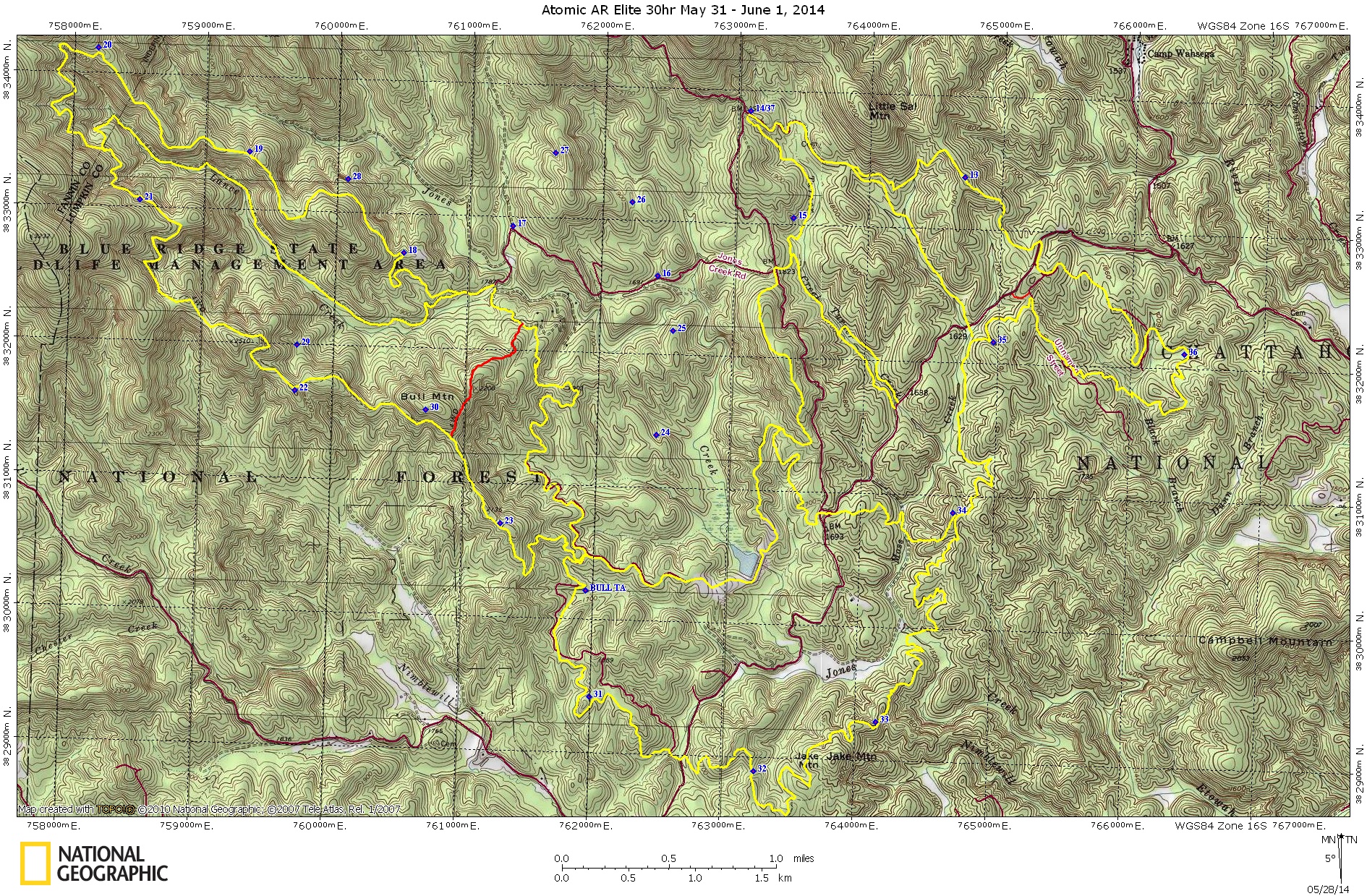
We got our maps and Stu and I started forming our plan. For the first time, we were using topographical maps and not Google Earth snapshots of the course. It took us awhile to get our bearing and figure out our course of action, but we decide on a plan to head north, pick up Hwy 60 and then get on Rock Creek Rd. Well, as soon as the race started and all of the racers head south instead of north, that plan was shot to hell. You see, everyone but us had decide to catch a shorter trail that would take them to Rock Creek Rd. I, of course, never saw the trail on the map.
The good thing about following other teams is that you learn something new, you sometimes are shown shorter paths that you never knew existed. The bad thing about following other teams is that sometimes they have no stinking clue where they’re going. Luck for us, everyone knew where they were going, so we just tagged along. And that’s when we discovered Georgia’s little secret, they have hills…big ones…some might even call them mountains. And the magical thing about these hills is that they always seemed to go up. I don’t recall a single downhill. Maybe they were there, but we were probably so lightheaded from sucking wind trying to reach the apex of the hills that the downhills didn’t register.
We found CP11 and CP12 without any difficulties and from there we started on some amazing single track to pick up CP13-CP23. Not having much single track experience and even less hill experience, this first bike section almost completely wiped us out. I don’t think that I’ve ever pushed a bike so far in my life. We basically got in the mode of pushing the bikes on the uphills and riding the flats and downhills. let’s just say that I’m pretty sure this was an 80% uphill to 20% downhill ratio. It took us 9 hours to complete the bike section. NINE! Aargh! We were the last team pulling into Bull TA. But, we did clear the first bike section even though we had to do some backtracking to get the CPs that we missed.
At Bull TA we realized how dehydrated we were and stocked up on ice cold water. There are many sources of water on the course and I regretted not picking up a water filter or Life Straw for this race, it would have really helped. After Bike 1, we set off on Foot 1, taking the checkpoints in decreasing order. I thought it would be easier to attack them going clockwise. CP30 was straightforward and we bushwhacked straight to it.
We then hit CP29, finding it without difficulty. From CP29, we bushwhacked straight north to the trail that ran along Lance Creek. After getting on the trail, we decided to stop for the first time and eat some food. We knew it would be a long time before we made it to our gear bins so we settled down to eat before it got too dark. We had packed some self-heating meals and I thought they were pretty good. Unfortunately, before that, I couldn’t really stomach eating any of the other food that we brought and the thought of consuming another gel almost made me puke. Our nutrition plan had failed us and no one was hungry for anything that we had brought along.
After dinner, we headed for CP28 and here is where things got really interesting. It started to get dark, really dark. Like, go in your room at night turn off all the lights then go into your closet and close the door and throw a shirt over your head, dark. The sky was overcast and the fog was rising from the mountains so there were no stars or moonlight. It was just black. On the way to CP28, we came across Crew Zen and they said there were a couple of teams looking for CP28 and they hadn’t found it and that they had lost their map for this section. They decided to move on to the next section and we went to look for CP28. While looking for CP28, we found Crew Zen’s map and also the checkpoint but we never saw Crew Zen again to return the map.
CP28 was a real high for us and we pushed on to CP27. Our plan for CP27 was to find CP17 and then follow the jeep trail north 550m before attacking due east for 400m. At first, we couldn’t find CP17 again. Once we did find it, we lost count of our paces going north and had to go back to CP17 to begin our pace count over. After counting the paces, we headed due east for 400m and looked around for the CP but never found it. We went in further and still couldn’t find it. Then, another team came past us in about the same area looking for it, so we were pretty sure that we were in the right area. By now it was starting to rain pretty hard and we couldn’t hear each other talking. Ana was on top of a hill serving as a beacon so we wouldn’t get too far off track and Stu and I continued to look for the CP. After awhile, I went in the direction that the other team went and came across them. They had found the CP, a little farther NE of where we were looking, and pointed me in the right direction. If it wasn’t for them, we would not have found it.
I regrouped with Stu and Ana and here’s where things went crazy. We knew we had to bushwhack due west to hit the north/south trail we had come up. However, looking at the terrain we could have sworn that the compass was pointing us in a direction we did not come. We felt that we had come almost 90 degrees to the left of where the compass was telling us to go. It was really hard to follow the compass west rather than the direction our minds were telling us to go. But in the end, the compass was correct. We headed west and thought we found the trail and began following it, only to discover that either we were never on the trail or had lost the trail. In the dark, things get really confusing and following a faint trail is very difficult. We knew that if we kept going, eventually we would come out to the main trail. So we bushwhacked in the rain looking and hoping that we would pop out of the woods at any second. It was raining hard, it was dark, we were confused and really tired. It was a real low point for me as I knew my navigation had failed and I was beginning to get worried that we were lost.
Eventually, we found the main trail. We were relieved but at the same time I knew the race was over for us. We decided to give CP26 a try, if we could easily find CP16 as the attack point. We halfheartedly walked towards CP16 but never found it, so we headed back to Bull TA to pick up our bikes and call it a race. Of course, we couldn’t find the red trail that was a shortcut back to Bull TA. I was absolutely pissed that we couldn’t find it I knew that I had seen the south exit of it when we were close to CP30 but I couldn’t find the north entrance of it. So, we had to walk the winding yellow trail going south to Bull TA. So frustrating.

By the time we got to Bull TA, I handed Drew our punch and asked him if he would give us a ride back to the S/F. He agreed and for the first time in the entire race I was scared enough to almost poop my pants. I don’t know who taught that guy to drive but Oh My GOD! does someone need to take his license. I swear we were going to die in a fire ball at the bottom of some cliff that he had sent us careening off of. White knuckled, shaking and scared completely awake, I told Drew thanks for the ride and we slinked back to our vehicle for a couple of hours rest before the long drive home.
So, what worked and what did we do right?
- Planning/Orienteering: Overall I think our planning and orienteering went pretty well. Yes, we did a lot of backtracking, especially towards the end, but we quickly realized our errors and found all of the CPs that we attempted with only 1 giving us some difficulty.
- Goal Setting and Expectations: Given the course, the duration and the competition our expectations were pretty low to begin with. We discussed the race beforehand and decided that we would attack it like a challenge and not a race. Could we push ourselves 30 hours, could we navigate in the dark, could we handle single track and hills, could we not end up killing each other? This is what we wanted to find out and use the knowledge in preparation for next year.
- Having Fun: My motto is racing at the speed of fun. In the end, if it wasn’t fun we didn’t do it right. No one is winning a big pot of money for doing these things, there are no medals handed out, so the only true reward is adventure and fun. Make sure that you’re not sacrificing 50% of your reward just to get points.
- Gear: I think for us, we packed well and I don’t think that we over packed.
What didn’t work and what did we do wrong?
- Nutrition: Our food and hydration plan completely failed us and we struggled immensely for it.
- Training: We were not prepared to handle the terrain of Blue Ridge, GA. We were also not skilled enough to handle the single track with any speed.
- Blow ups: I had two blow ups directed towards Ana during the race for which I am immensely sorry. It isn’t acceptable and I will try my best to not let it happen again. I don’t find it acceptable to blow up at your teammate and especially if that teammate is someone you love with all your heart.
Conclusion:
Some might wonder why we continued with Foot 1 rather than moving on. The answer is that by the time we started Foot 1 it was already dark and given our lackluster performance on the single track during the day, I didn’t think it would be wise to do Bike 2–even more single track–at night. Since we were already night orienteering, there wasn’t any reason to quit Foot 1 to do Foot 2, which was more night orienteering. The only thing that would have made sense to move on to was the canoeing section. But, we would have to bike from Bull TA to the canoe TA at night. Then, we would have to take Class II rapids in our already tired mental and physical state. This didn’t seem wise to me or the team, so we called the race and went to Waffle House instead.


Awesome! Thanks for posting maps. The Fool’s Gold 100 mtb race goes through that area, and it was cool to see it from an AR perspective. Congrats on sticking together and keeping it fun, Waffle House FTW! That terrain is no joke, either. Very tough!
Waffle House has become our post race go to spot. I should have taken a photo, we had the entire table covered in food. Blue Ridge GA is amazing. 100 mile mtb race on those hills? My legs are cramping just thinking about it.
Pingback: Ramblings and Musings